
-

- Bison. We shared the rest area with them. Or they with us? It was along Interstate 90 on the road to Alaska. We were in Western North Dakota.
-

- Banff National Park is in the Canadian Rockies of Western of Alberta. Notice the jagged mountain scenery sculpted by the glaciers during the most recent ice age.
-

- Mile “0” of the Alaska Highway in Dawson Creek, British Columbia. The monument is in the middle of the intersection. After Pearl Harbor, this road to Alaska was built in one year by the Army.
-

- It took us 10 days from Buffalo to reach this sign. See the red Ranger in the background. This highway is one of two roads into the main part of Alaska. The other is a gravel road further north.
-

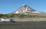
- Reboubt had a major eruption in 1990. It shut down Anchorage air traffic. Then it erupted again in April 2009, a month before our visit, and was still erupting when we flew by it in June. It is 10,197 feet high. There is very little snow because it is hot underneath.
-
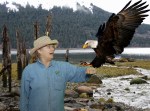
- Doc Harris and eagle. She has always wanted to hold one, and in Alaska it happened.
-

- Yukon River over central Alaska, from a plane north from Fairbanks.
-
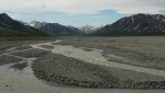
- The Toklat River is typical glacier fed braided stream. This occurs because there is a high supply of coarse gravelly sediment and variable river discharge. (flow)
-

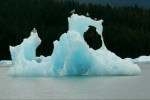
- We were in a little boat. This iceberg is stuck on the submerged moraine near the mouth of Le Conte Bay east of Petersburg. Notice that the iceberg is blue and yet pieces coming off it are lighter.
-
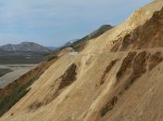
- This narrow road carved into a rocky steep hillside in Denali National Park. Its part of the Kantishna Road House bus route where we panned for gold. It is a private road. Its called polychrome from the many colors of the weathered rock.
-
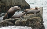
- Stellar sea lion’s resting on rocks in the Kenai Fjords National Park. The bull male on the left is much larger than the females and pups. These sea lions are much bigger than the ones you see in California.
-

- The Stikine river is in the coastal mountains east of Wrangell. It is very shallow, and can only be reached by flat bottomed boats.
-

- This image was taken on a whale watching tour near Petersburg.
-
- Iceberg calved off the La Conte Glacier get stuck on the submerged moraine, flip over many times as the tide goes in and out. Each berg becomes its own ice sculpture and bird perch.
-

- This 14 story mill was at one time the largest copper mill in the world. It is no longer operating.
-

- Juneau, capital city of Alaska. It is the only state capital that you cannot drive to it from anywhere else. This picture, from a helicopter, shows four cruise ships visiting the capital.
-

- Iliamna is another active volcano just south of Redoubt. It is 10,016 feet high. Notice that it is covered in snow because it is not currently hot.
-

- Homer, Alaska is in the Cook Inlet. The spit protrudes into the bay making it a safe and inviting harbor.
-

- Harbor seals come into La Conte bay to give birth and climb on icebergs. They escape orcas, killer whales, and provide entertainment for visitors to the bay.
-
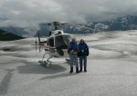
- From Juneau you can visit the Juneau Ice Field. We landed on Taku Glacier. It was cold!
-
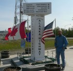
- Mile 1422 at Delta Junction is the official ending of the Alaska Highway. It is 3,847 miles from New York City. Some people think the highway goes all the way to Fairbanks.
-

- This picture was taken from the second story window of our lodging in Petersburg, AK. Bald eagles are common in this area.
-
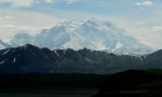
- The highest mountain in North America at 20,320 feet. It stands above all the other lower mountains and is so high that it makes its own weather. Only 30% of visitors to the park ever see its summit because of clouds.
-
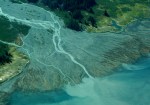
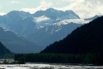
- This is one of many deltas formed by rivers flowing from the Chugach Range into the sound. Seen from the air.
-

- This black bear was on the trail to the retreating terminus of Exit Glacier in Kenai Fjords National Park. he moved on and Rick kept on his hike. Robin stayed in the truck.
-
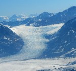
- The Colony Glacier is one of many glaciers in the Chugach Range along Alaska’s southern coast east of Anchorage. This is an aerial shot.
-

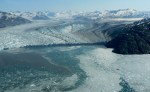
- In flows into Prince William Sound, the columbia Glacier is one of the largest tidewater glaciers. This is an aerial view showing how irregular the face of the glacier is. Notice the calved icebergs and the blue color of the glacier. It is blue because glacial ice is not formed by freezing water but by compacting snow. The pressure drives out the air and makes a denser ice. The blue light from the sun’s solar spectrum reflects off this ice.
-
- Augustine volcano is 4,025 feet high and is active. Our plane landed on the beach of this uninhabited island at low tide. Robin found a note in a bottle from an Anchorage middle school student doing a science project on the currents in Cook Inlet.
-
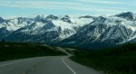
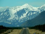
- Coastal Range in South of Haines Junction, Yukon Territory on the way south to Haines, AK.
-
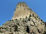
- Believed to be a Volcanic plug, left behind as the surrounding land was eroded away.
-
- We were driving south to Haines, AK. We stopped at the Chilkat Bad Eagle Preserve Council Grounds.
Alaska, Summer 2009. We drove from western New York and back on a 45 day trip where we drove over 12,000 miles. We didn’t count the Alaska Marine Highway ferry miles as the red truck was stationary. Here are some pics that highlight that trip.

August 6, 2014 at 3:22 pm
Cuz, after watching your slide show I feel like I took the trip with you! What a beautiful country we live in!
August 7, 2014 at 7:44 pm
Thanks cuz. we sure loved that trip. we hope to post more pics as we get better at this. And we did spend 38 days in australia and new zealand. lots to share about this trip. love you